Urban Planning and the Struggle Against Israel's Spatial Domination
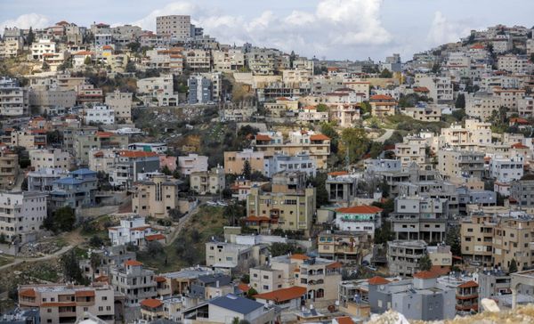
Located in Wadi Ara within the Green Line, Kufr Qara is a Palestinian town of 20,000 residents.
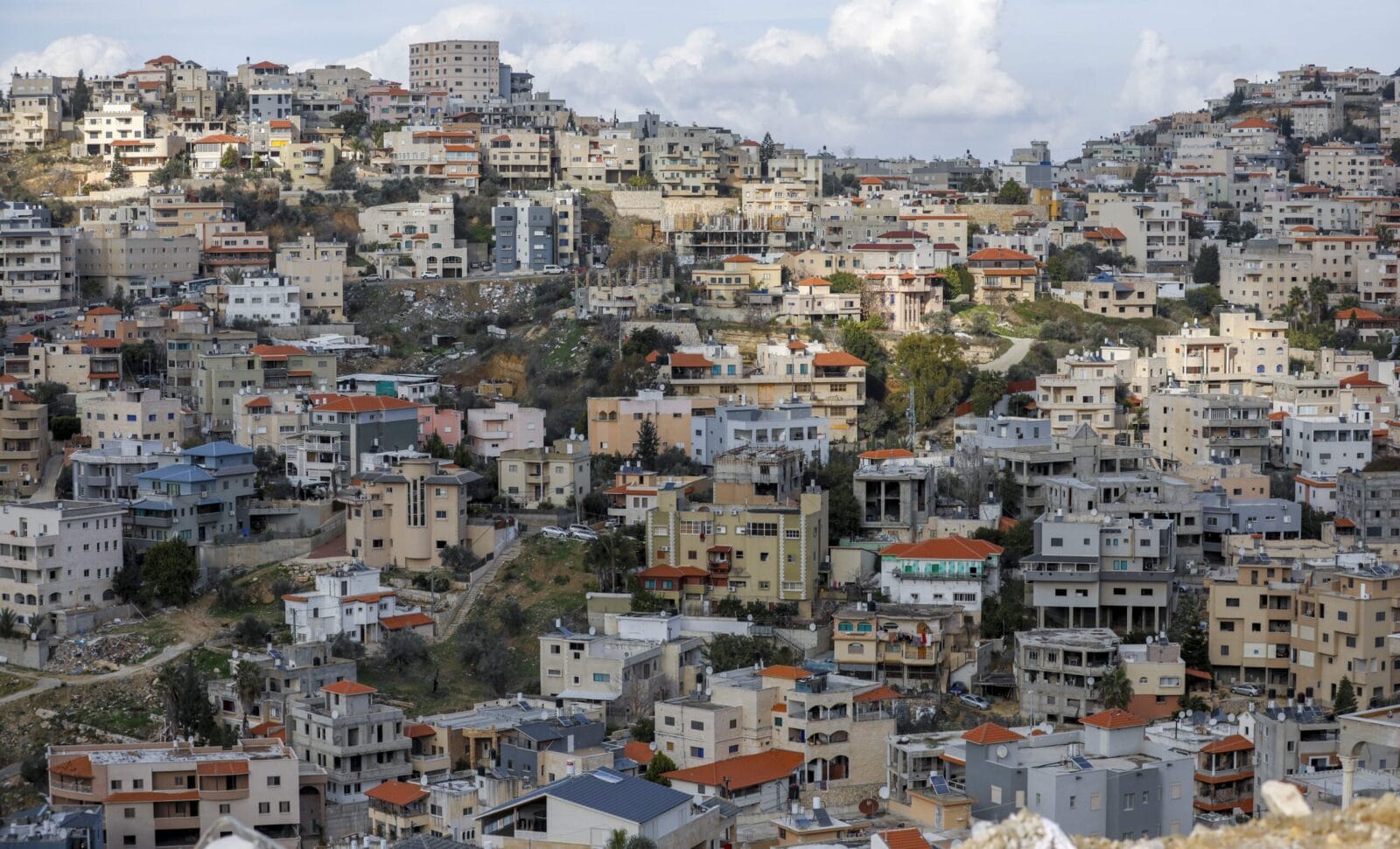
Before the Nakba, its land spanned 28,000 dunums (roughly 7,000 acres), but today, Israel has left it with less than 8,000 dunums (fewer than 2,000 acres).
The town is encircled by Route 6 (a highway stretching north to south), an Israeli military camp and the Jewish settlements of Menashe Regional Council. Like many ’48 Palestinian towns, it faces a significant planning crisis. Its last master plan was approved in 1982 and allows for development on only 2,300 dunums, leaving most of the town's land designated strictly for agricultural use. As a result, over several decades, residents have constructed more than 2,000 unlicensed buildings, which lack connection to the formal electrical grid and other essential infrastructure.[1]
In recent years, the grave and mounting repercussions of the housing and planning crisis in ’48 Palestinian towns and villages have compelled Israel to recognize the problem. After decades of strategic neglect that has turned these towns into ghettos dotting the Israeli map, the state began initiating and funding a wave of master plans for these towns, including Kufr Qara’, framing its efforts as a solution to the shortage in housing and urban development. One of the Israeli urban planners responsible for planning in Kufr Qara’ captured this view in a conversation we had in 2022: “Isn’t this current planning considered a fair solution to historical dispossession?” He asked. “Instead of thousands of dunums of agricultural land that today hold no real estate value, the people of Kufr Qara’ will receive residential, industrial and commercial lands valued at hundreds of millions. So what if it’s only a quarter of the historical area?”
His question, and the planning situation in Kufr Qara’ more broadly, speak to the deeper injustices at the heart of the current urban planning wave in ’48 Palestine. This “fair solution,” has been imposed by the Israeli government and works to shape and limit professional and political trajectories for Palestinian urban planning. As such, it is an extension of a longer colonial project—an arc beginning with the first Zionist spatial planning strategies during the British Mandate and including the hundreds of plans that Israel suggests as solutions today.
Within a few years of the Nakba, Israel had claimed ownership over 93 percent of the pre-1967 territory. Enacting the “Absentee Law,” the state confiscated the lands of Palestinians who had been driven out and, in accordance with British Mandatory laws, took control of all unregistered lands. It also transferred property controlled by Zionist organizations, like the Jewish National Fund, to state ownership. The high percentage of state-owned land enabled the Israeli government to tightly regulate urban planning and implement its national strategic objectives. In an exercise of colonial mapping, the new Zionist state looked at Palestine from above and literally reshaped the map.
Key to the state’s spatial domination was a planning policy that dispersed Jewish immigrants across vast swaths of land. The goal was to preempt efforts of Palestinian refugees to reclaim the land and prevent a return to the 1947 UN partition lines. Beginning under the British Mandate and continuing with partition, hundreds of new low-density agricultural settlements and “development towns” were built in nationally strategic areas like the border regions, the Galilee and the southern desert of the Naqab (or Negev, as it is called by the state today). Israel used appropriated lands to establish industrial zones, plant forests, extend roads and build facilities to provide water, electricity, gas, construction materials and other resources for developing the newly established state.
On the margins of the developing and flourishing Zionist project, Palestinian villages were confined, under military rule, to less than 2.5 percent of the newly declared state.
On the margins of the developing and flourishing Zionist project, Palestinian villages were confined, under military rule, to less than 2.5 percent of the newly declared state.[2] Settlements, infrastructure and natural reserves surrounded them, leaving these villages as isolated enclaves. As a result of these confines, ’48 Palestinians were forced to build on agricultural lands and open spaces. In most cases, this kind of building occurred on an individual level, with little prior organization and without official planning to meet population needs.
The number of ’48 Palestinians has increased 11-fold since the Nakba. 90 percent live in Palestinian-only towns, which have been deliberately neglected by Israeli planning. As a result, rural villages have come to resemble overcrowded residential slums, with tens of thousands of homes built without permits and facing demolition orders. They suffer from a severe lack of infrastructure, open spaces, public services and employment opportunities. At the same time, Palestinians are barred from living in hundreds of Jewish-Israeli “community towns”—settlements built on state land and run as cooperatives—due to racist admission policies that were recently expanded by the government to apply to larger towns. Moreover, the lack of necessary social and educational services in Arabic prevents Palestinians from living in other Israeli Jewish cities.
The boundaries of Palestinian villages within Israel are well-defined and carefully maintained—the Israeli demolition machine efficiently prevents the construction of even a single room beyond the stipulated limits. But the crises that have persisted for decades in these villages were bound to escape their confines and become an issue for the Israeli state.
In 2007, when Israel first attempted to join the Organization for Economic Cooperation and Development (OECD), it was forced to pay attention to the conditions faced by ’48 Palestinians. The OECD has released several reports highlighting substantial disparities between Palestinians and Jews in various sectors, including the economy, education, employment, infrastructure, budgets, industrial zones and transportation. A 2009 report, for example, highlighted that 50 percent of Palestinians live below the poverty line.[3] The OECD warned that these disparities would impact the Israeli economy given that Palestinians make up about a fifth of the population.
The OECD warned that these disparities would impact the Israeli economy given that Palestinians make up about a fifth of the population.
The lack of economic opportunities and restrictions on building in Palestinian towns—which causes an annual housing shortage of 5,000 units—have driven many young Palestinians to seek housing and employment in Jewish cities like Nof Hagalil, Ma'alot, Karmiel and Harish.[4] As a result, settlements that were initially established to disperse the Jewish population and Judaize the Naqab, Galilee and central Israel, have become a refuge for Palestinians and a perceived threat to the Jewish character of these cities.
In 2020, a magistrate court rejected a lawsuit on behalf of two Palestinian children in Karmiel whose families had requested transportation services to the Arab school in a neighboring village. In his statement, the judge who ruled on the case wrote, “Karmiel is a Jewish city built to promote Jewish settlement in the Galilee. Funding transportation for Arab students may change the demographic balance in it and alter its Jewish character.”[5] The judge grounded his decision in the 2018 Basic Law, which declared Israel as the Nation-State of the Jewish People and which prioritizes the development of Jewish settlements as a supreme national value.
In Nof Hagalil, a Jewish settlement near Nazareth, Palestinians are expected to make up 40 percent of the population by the end of this decade.[6] In response, the city administration has continuously incited hostility against Palestinian residents. In 2013, for example, its mayor won with the slogan to keep the city is Jewish “now and forever.”[7] The city’s street signs are not in Arabic. Only one community center offers activities in Arabic for the youth, and over the years the administration has refused requests to open an Arab school. The administration has also joined forces with various settler organizations to actively encourage ultra-Orthodox Jews to move to the city. These efforts have paid off. In the first six months of 2023, the city granted approval for the construction of an ultra-Orthodox Jewish neighborhood, comprising 3,300 housing units.
At the 2022 International Institute for Counter-Terrorism conference, Ronen Bar, the director of the Israeli Intelligence Agency, stated, “Israel is transforming from a state with mixed cities to a mixed state, posing a major challenge to the public.”[8] His words underscore how ’48 Palestinians, and their movement to Jewish towns, present not just a social but a security challenge to the Jewish state. In this context, the recent governmental urban planning initiatives in Palestinian towns should be understood, critically, as a strategy to reinforce segregation while reducing Palestinians’ economic burden on the state.
In December of 2014, the Israeli government formed a working group to develop a plan to address the housing crisis in minority towns. The group put forward a number of practical recommendations related to planning and construction, including expanding building areas in Palestinian towns, establishing local planning committees, training engineering teams in local government and easing bureaucratic obstacles to land registration and small-scale plan submissions. They also suggested the government encourage intensive construction on private lands. A government economic plan for the years 2016–2020 set aside funds explicitly for implementing these recommendations, and in 2021, funds were expanded for another five years.
These steps are a marked shift. In contrast to past decades, when the Israeli government primarily influenced Palestinian towns through restrictions and neglect, it now acts as a major player in financing and planning within them. Israel is now drawing lines on the remaining scarce lands that were off limits to urban planners before. Crucially, however, in its efforts to “solve” the housing crisis, the state is using the very same planning system, maps, pens and laws that were instrumental to Palestinian dispossession.
At the top of the state’s planning hierarchy are the National Outline Plans (NOP). The first of these plans was established in 1951. They cover the entire state’s territory and hold the highest legal authority. NOPs specify everything from the locations of cities and towns, their population densities, the open areas around them, the various infrastructures, future development boundaries, coastlines, airports, basic public institutions and other structures that Israel strategically develops with the long-term vision of the state. These plans are discussed by the National Planning and Building Council—the highest planning institution in the country—and are approved by the Israeli government. Under the umbrella of the NOPs, smaller-scale plans are formed to address local districts or regions and provide detailed plans to achieve the basic vision set by the NOPs.
Yet, when it comes to the broader questions of “Where do we want to live?” or even "How do we want to live in these towns?" Israel has consequentially predetermined the answers for us.
Palestinian towns in Israel fall under these NOPs and are affected by them at all levels. A Palestinian town does not determine its borders, its population density, transportation and street standards or other strategic decisions. As such, Palestinians cannot plan according to our own visions for the space in which we live. Even if the new wave of plans is approved (itself not a guarantee) the decision-making space they offer is limited. These plans may slightly organize the space and allow residents to obtain building permits for their houses, while providing necessary infrastructure. Yet, when it comes to the broader questions of “Where do we want to live?” or even "How do we want to live in these towns?" Israel has consequentially predetermined the answers for us.
On the question of where Palestinians can build, it is almost impossible to find available state lands for construction. They are either located outside the municipal jurisdiction of Palestinian towns—making it difficult to annex and plan on them—or they are not designated for development and construction by the NOPs. Any new planning for Palestinian towns is therefore likely to be implemented on private (primarily agricultural) land. Most ’48 Palestinians do not own agricultural lands and so will be dependent on landowners’ decisions to invest and sell. This dependency—by converting landowners into potentially wealthy investors—could work to solidify existing social and material disparities. It also links housing and development solutions to the free market and individuals, thereby shifting responsibility from the state that generated the crisis to us, the victims of this crisis.
Moreover, for landowners, development will not be a straightforward process. These privately owned agricultural lands have historically been registered through a communal ownership system (Musha`), whereby each large parcel of land is owned collectively by many individuals from different families and passed down intergenerationally through inheritance. As this land gains real estate value, people will be forced to re-divide the shared properties in order to obtain permissions for construction—a process fraught with bureaucratic, legal and social obstacles.
On the question of how Palestinians can build, again the answer comes from the NOPs and the needs of the Israeli state. In 2006, with the approval of NOP 35/4, Israel has shifted from an approach centered on dispersing its Jewish population at a low density throughout the land to a national policy of densifying existing cities by prioritizing building in existing neighborhoods over developing new ones. For Palestinians, these changes mean that the plans, if approved, will inflate the number of housing units per parcel of land. The units themselves are unlikely to be built. In addition to bureaucratic obstacles, many of the current plans for more units involve constructing them on top of existing buildings that cannot accommodate additions, and many of the land owners are not willing to turn their lots into housing projects.
The use of private lands to address the housing crisis calls into question the state's claims to be solving the problem—as does the state’s ongoing demolitions of Palestinian homes. In 2017, the “Kaminitz Law” was ratified. The amendment grants planning institutions the power to issue demolition orders and monetary fines for unauthorized construction, threatening tens of thousands of unlicensed houses in Palestinian towns. In areas undergoing a planning process, this law is particularly intensely enforced, meaning houses are at higher risk of demolitions or fines. Even in the absence of demolitions, the law requires a complete freeze on construction in these areas until the final plan is approved—a process that takes years.
Notwithstanding these many obstacles and incongruities, if the free market manages to build and sell these units successfully due to high demand, what kind of spaces await us? Towns that have distortedly developed from villages into densely populated areas without adequate infrastructure will have more crowded zones added to them. Meanwhile, existing built environments and social configurations will be eroded. What quality of life can be expected in such towns?
Perhaps the clearest success of Israel’s urban planning project has been in transforming the political crisis facing ’48 Palestinians into a problem of numbers and a shortage of properties.
At the professional planning level, as well as at the general political level, our vision for our future has become confined to the tools provided by the Israeli state. Too many of us are only asking questions such as, “How many housing units do we want?” Or “how many new dunums have we added?” As for the deeper questions about how and where we want to live, the shape of our neighborhoods, parks and social life—they remain foreclosed to us.
Returning to the question that the Israeli urban planner put to me: Is Israel’s current planning a “fair solution” to its historic dispossession of Palestinian land? It is not a fair solution. It is not a solution at all. Even as Israel claims to advance the interests of Palestinian communities, the state simultaneously pushes forward colonial planning strategies aimed at preempting Palestinian challenges to its domination. For example, following the Unity Intifada in May of 2021, the Israeli army extended 994 miles of roads for its use during times of unrest, preempting Palestinians from blocking roads in protest. This strategy is reminiscent of the bypass roads built for settlers in the West Bank. At the same time, the state is advancing plans to establish five new Jewish settlements in the Naqab.
The struggle against Israel’s spatial domination of Palestinians does not only require asking new questions. It also requires planning beyond the borders of Palestinian towns and villages. Palestinian planners must envision our professional work within a broader political framework oriented toward a communal Palestinian horizon rather than narrow and technical solutions. We should create new approaches to planning that help us reclaim authority and decision-making over our land: through community organizing, non-governmental initiatives and funds, new planning toolkits and broader Palestinian collective work with organizations from the West Bank and Gaza. Such collective work will enable us to build resilient and sustainable Palestinian communities rather than accepting desperate, crisis-driven solutions.
-- Translated by Maha Nassar
[Lama Shehadeh is an architect and urban planner who graduated from Cornell University. She currently works in planning for '48 Palestinian towns.]
Read the previous article.
Read the next article.
This article appears in MER issue 309 “Palestine—Before and After October 7.”
[1] "Planning and Regulation in the Arab Settlements," The Arab Center for Alternative Planning & Sikkuy-Aufoq, May 2022. [Hebrew]
[2] Oren Yiftachel, “Lands, planning and inequality: the division of space between Jews and Arabs in Israel,” Adva Center Position Paper, November 2000, p. 15. [Hebrew]
[3] OECD: “OECD Economic Surveys: Israel 2009.”
[4] “Annual Report,” State Comptroller's Office and Public Complaints Commission, 2019.
[5] Noa Shpigel, "The High Court approved the deletion of the claim of Arab children from Karmiel through the Nationality Law,” Haaretz, November 30, 2020. [Hebrew]
[6] Guy Nardi, “Roof agreement in Nof HaGalil for the construction of 7,000 apartments - the state will invest NIS 2.3 billion,” Calcalist, November 7, 2022. [Hebrew].
[7] William Booth and Ruth Eglash, "High above Nazareth, an Israeli mayor wants to keep his city Jewish 'now and forever,’" Washington Post, September 20, 2013.
[8] Amir Bohbot, “Head of the Shin Bet: The violent discourse on social networks encourages terrorists,” Walla News, September 11, 2022. [Hebrew]